Day 1 (6:30 am) Oberlin, Ohio
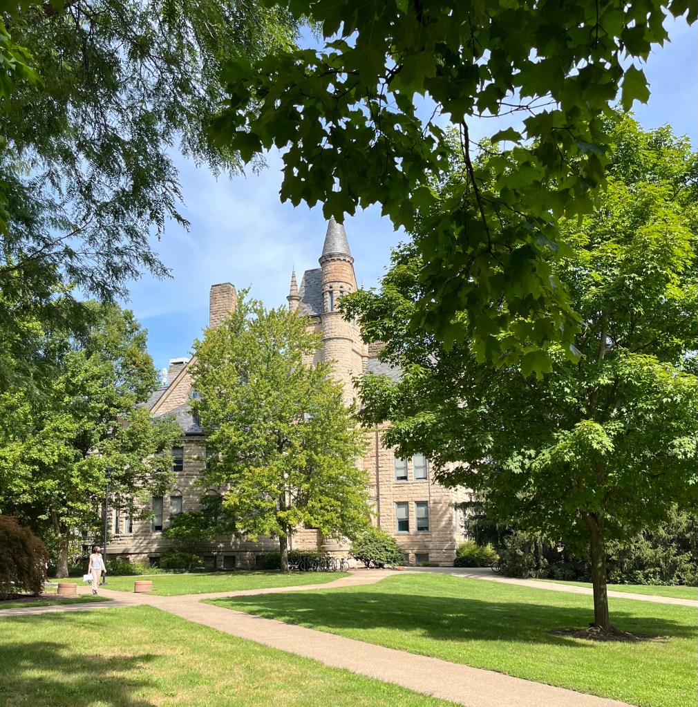
On a drizzly morning at the end of May, Helen sat beside me as we drove slowly out of Oberlin. We took in the familiar college buildings surrounding Tappan Square one last time. The enormity of it all settled within both of us. The excitement and bustle of graduation weekend, filled with celebrations and award ceremonies and gatherings, had come to a close. We had packed up her apartment and loaded her belongings into the car. She bade her friends farewell, promising to stay in touch, shedding a nostalgic tear or two. It was time to start our long drive back to Alaska.

Perhaps for different reasons, caught up in our separate pasts, the departure was bittersweet for us both. Oberlin College had become a family legacy. I wanted to tell her how the school, in the days when her father and I were students there, had been an anchor as well as a springboard for our future. It promised us a life beyond, a solid footing, the groundwork for our future. I knew she had made her own experiences, that times had changed even in the overlap of years that saw her and her older brother walking along the same crisscrossed paths of the campus. My college, seen through her eyes. It was different. It had also remained the same. We had absorbed the teachings written on the walls of the academic buildings – Kettering and Severance and King. We had listened in lecture halls and read until late into the night. We learned to think and to question, to love and to thrive. We left with gratitude in our hearts for the place that shaped us.
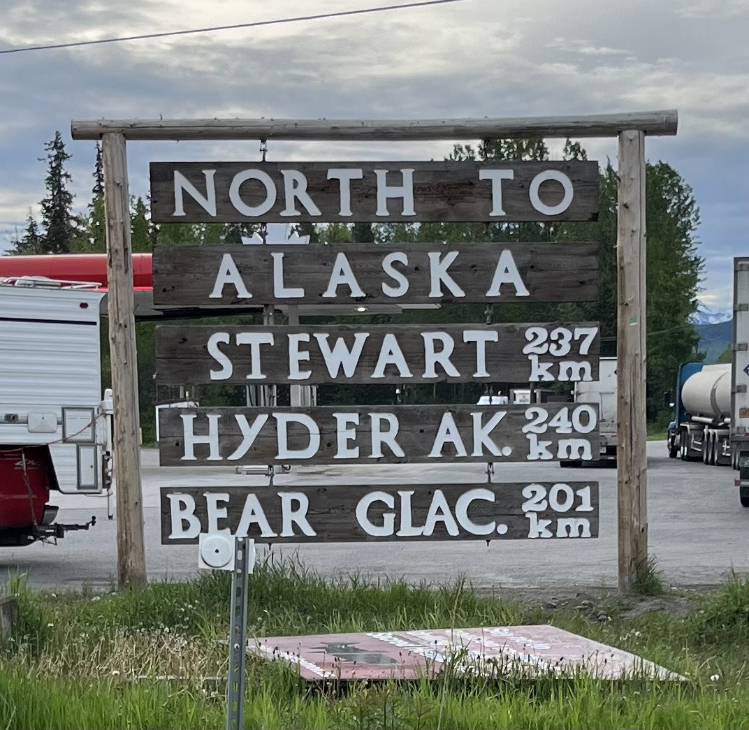
Helen and I planned our upcoming journey. I consulted an atlas and Helen loaded our route onto Google maps. We studied The Milepost, the “bible of north country travel.” We had heard descriptions of our intended route. The road would take us across two border crossings and four time zones. We would traverse eight states in the United States, two provinces and one territory in Canada, and finally Alaska.
We got some advice from Alaskan friends who had driven the road: Bring an extra car tire. You do know how to change a flat, don’t you? Fill your gas tank and an extra gasoline container whenever you come across a gas station, especially in remote areas. Be prepared to be “off the grid” without cell phone service for long stretches of time. Watch out for bears on the “wilderness highway.” Helen and I looked at each other. What kind of adventure had we agreed to embark on?
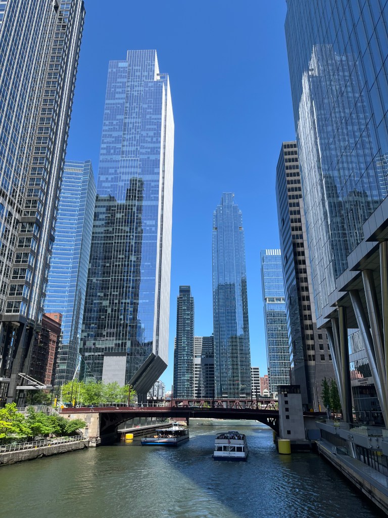
We drove west on I-90. After the rain in Ohio, the weather turned dry and sunny in Indiana. We sat back, sipped tea in our to-go cups and looked out at the scenery. At midday, we saw the skyline of Chicago on the horizon. For a moment, we pondered stopping to visit Yanni for a few hours. The interstate led us close to downtown into proximity of his medical school campus. We knew he would be studying in his apartment. But when we got snarled in five lanes of congested traffic with cars weaving in and out at high speeds, I decided to forgo the detour. With my heart pounding, urged by Helen to “drive aggressively,” I was glad we made it through the city without hitting another car. It would have been nice to see Yanni, but I consoled myself knowing we had just spent the weekend catching up with him in Oberlin. Plus, we were determined to make good time on the first day of our trip.
Cities segued into open country. In Wisconsin, Helen announced that she wanted to buy some cheese. We drove around in vain looking for the cheese the state is known for, finally finding some at an Aldi store. We crossed the Mississippi River into Minnesota, impressed by the broad waterway whose banks shaped the contours of the states it flowed through. In southern Minnesota, the green plains were dotted with a multitude of grazing cows. We challenged each other on our agricultural knowledge. Which was it, the grain silo or the grain bin, that stored the dry grains for human consumption and which one was filled with silage that feeds livestock throughout the winter? When we encountered wind farms with hundreds of wind turbines, our conversation turned to the importance of alternate energy sources. Passing by smaller towns – Albert Lea, Fairmont, Worthington – whose names were proudly displayed on water towers, we discussed the pumping mechanism of water to the towns’ residents. When we grew tired of talking (and consulting Wikipedia), we simply looked out of our windows in companionable silence. We stopped for the night just short of Sioux Falls.
Day 2 (8:30 am) DeSmet, South Dakota
There was something breathtaking about the open prairie. Gazing out at the expanse of land beneath a wide sky made us feel miniscule. Naturally, our thoughts veered to early settlers, brave enough to conquer the terrain and the weather. I thought of Dances with Wolves and 1883. A friend of mine once told me she longed to go to the Library of Congress and hold a first edition copy of “Little House on the Prairie” in her hands. Before an endlessly unfolding terrain, with the wind in my hair that morning, I knew what she meant. The ribbon of road ahead was straight and far reaching, undulating softly. Yet another horizon offered itself to us.
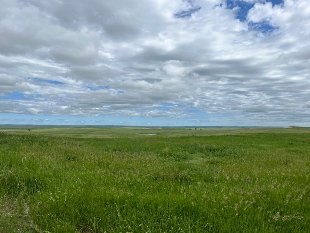
We took our cues from the land. The landscape changed daily, and our enthusiasm swelled in response. We mapped out landmarks along the way, excited about what the day would bring.
We traversed the Bad Lands of South Dakota. I could understand how pioneers, with horses and covered wagons, would have encountered difficulties negotiating this land after the gentle, waving grasses of the prairies. Nearing the Black Hills, the landscape and rock formations became more rugged. The dark green of the Ponderosa Pines made the rocky hills look black.
We went in search of Mount Rushmore. When we came to it, the sculpted faces on the granite mountainside were even more imposing than I had imagined. We marveled, from far below, at the technical challenge of the massive scale, the prowess of a sculptor using a mountain as his studio to carve the faces of four presidents. Using dynamite and jackhammers to blast off rockface, then hammers and chisels to buff and smoothen, carvers followed Gutzon Borglum’s design to commemorate America’s first one hundred and fifty years of history in what he called a “shrine to democracy.”
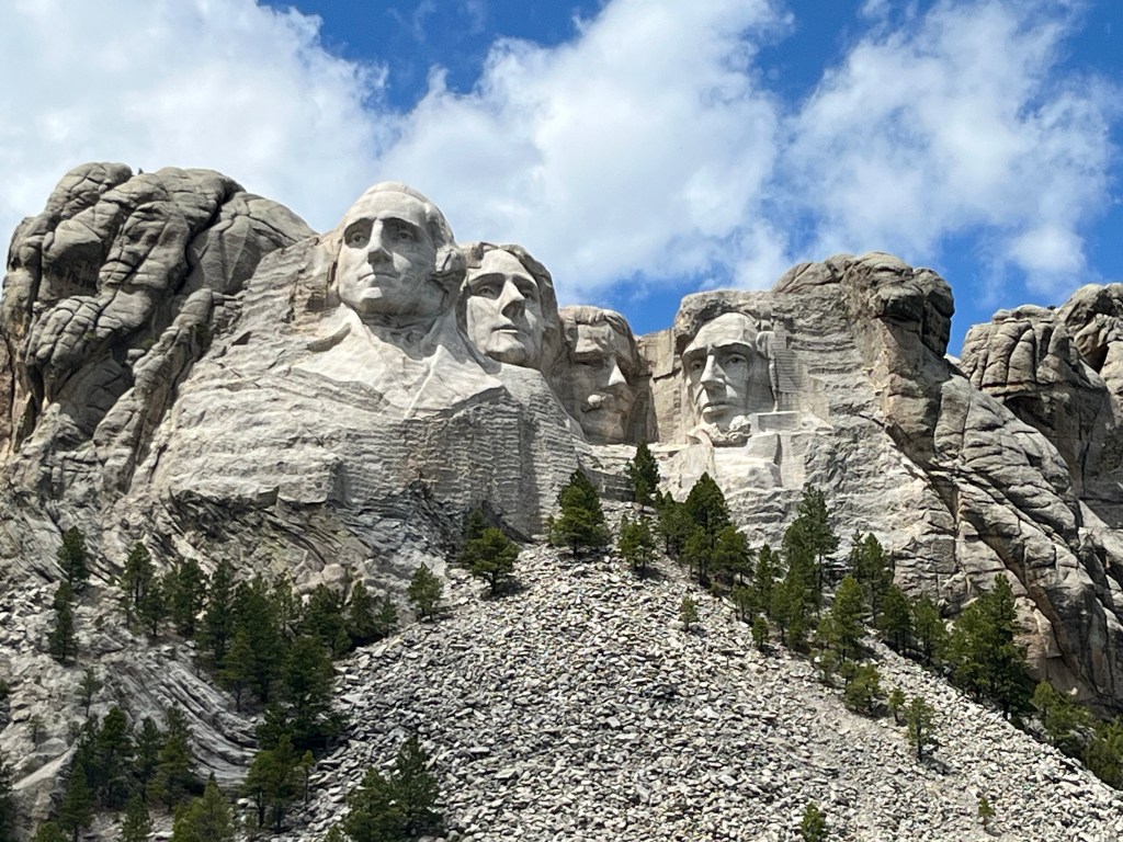
As impressed as I was with this giant earth artwork, it was not untouched by controversy. The sculpture was built on land the Lakota Sioux regard as their own, a place for prayer, a medicinal resource, a hunting ground. To this day the conflict continues. In light of this, our next stop, not far down the road, was to see an even larger, albeit unfinished work-in-progress. The face of Crazy Horse, a Lakota warrior and leader, was sculpted from a different mountainside. The rest of him would slowly be liberated from the granite, it was estimated, within another decade. Crazy Horse’s portrait, conceived by Henry Standing Bear and carried out by Korazak Ziolkowski, paid tribute to the culture and its traditions. Even if its completion had not found an exact timeline, it is a poignant symbol even now and would undoubtedly survive the ages.
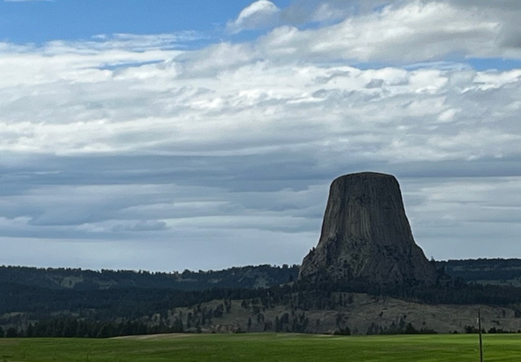
Not long after we crossed into Wyoming, we drove a detour to see Devil’s Tower. Another rock formation, this time formed by nature. A huge igneous butte rose tall above the Belle Fourche River, a rare geological example of columnar jointing, we learned, which resulted in its textured, striped look. Although we did not have the time to hike around it, the tower was an imposing sight even from a distance.
Day 3 (5:40 am) Sheridan, Wyoming
While we logged miles, we listened to Jennette McCurdy’s audiobook “I’m glad my mother died.” I want to think that Helen chose the book because of its gripping narrative, not because it insinuated anything about our relationship after three long days in the car together. After many hours of driving, we understood why Montana is called “Big Sky Montana.” We drove on and on, through ranch lands and small settlements with just a handful of houses and fields of grazing cattle. We came by the site that commemorated the Battle of Little Bighorn which saw the defeat of Custer and his cavalry by Lakota Sioux, Cheyenne and Arapaho warriors. Further down the road, we drove by the Crow Nation Reservation. History, at every mile in the road, hung thick in the air.
We crossed the border into Canada at Sweetgrass and made our way north toward Calgary. Prone to entertaining ourselves with just about anything by now, we pointed out Canadian idiosyncrasies we noticed on the road. Signs warned that seatbelt wearing was “compulsory” and trucks should engage “retarder brakes” in residential zones. When we watched a car get pulled over by a “peace officer” for speeding, we quickly fidgeted with the car’s settings to change the display from miles to kilometers. We were impressed with the clean highways and beautiful surroundings. Once we got through Calgary, we turned west towards Banff and Lake Louise. Helen squirmed in anticipation. They were two spots she had marked on the map.
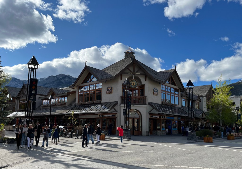
Our excitement grew as the Canadian Rockies rose in front of us in an evening light that was silvery and soft. Banff reminded us of southern Germany. It had the look of a small, alpine town, mountains towering peripherally, pedestrians walking to eateries and shops along the main street. It was groomed and quaint and charming. Secretly, we thought tourist attractions in Alaska, for all their endearing ruggedness, could learn a lesson or two from the Canadians.
Day 4 (6:45 am) Banff, Alberta
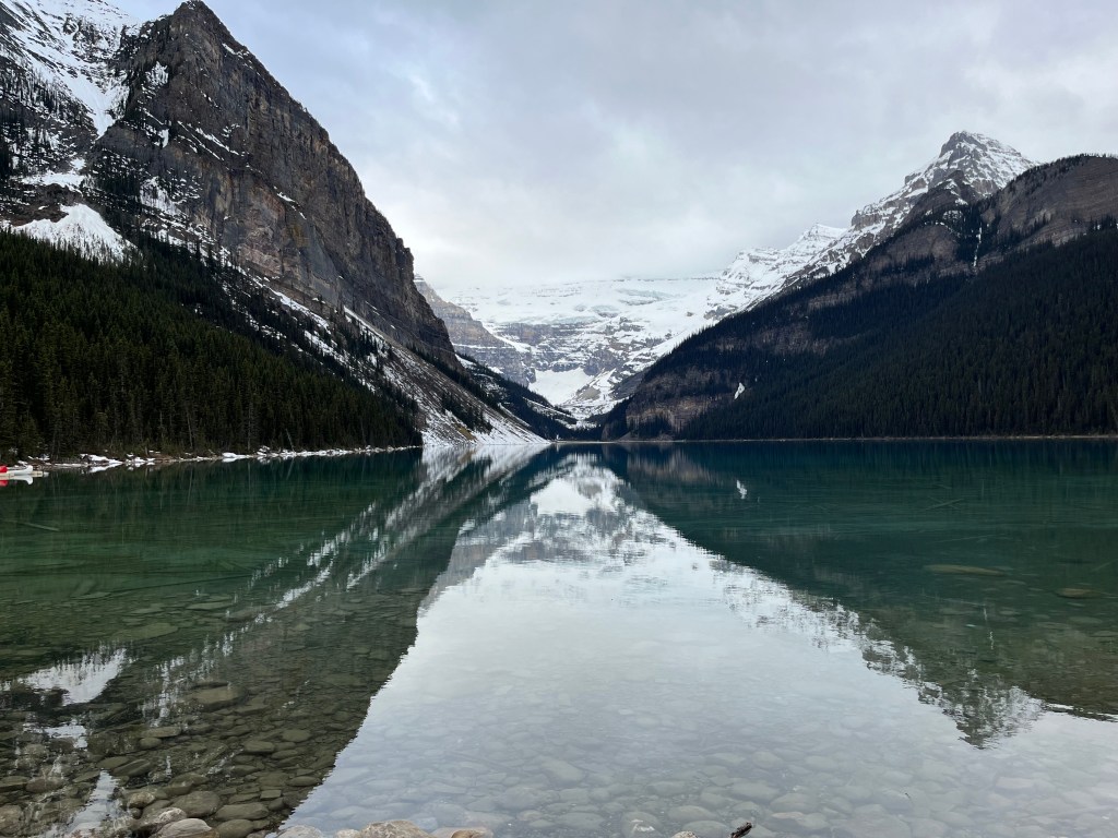
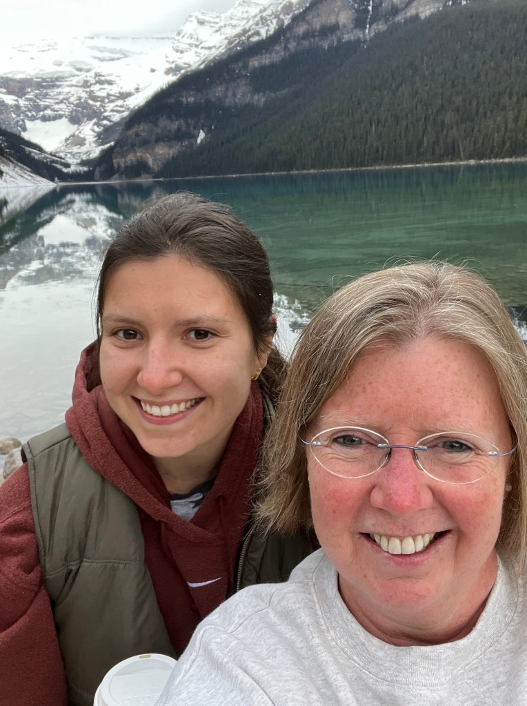
We rose early to get to Lake Louise because we read that parking was limited near the lake. True enough, even though it was not even 7 am when we arrived, parking attendants had already filled half of the parking lot. Now we really were curious about the lake that attracted so many visitors! At the parking kiosk, we stared incredulously at the fee: $37 for the day! We decided to risk a fine, skipped paying, and walked down to the lake. It lay silvery and pristine in the early morning light, snow-capped mountains symmetrically reflected in its smooth surface. Hordes of tourists stood at its edge, near the imposing Chateau Lake Louise hotel, taking selfies. Helen and I gazed out over the water for a few minutes and decided that this lake, while beautiful, was about as enticing as any other mountain lake in the area. Whether or not its attraction was the result of media, we were glad to have stopped for a sight of it.
We certainly hadn’t bargained for the beauty of the Icefields Parkway which connected Lake Louise to Jasper in Alberta. I had read that the road traversed the Continental Divide and traveling it was like driving on “the backbone of the North American continent.” The high road, one of the most scenic I have ever taken, took us close to glaciers and lakes that were still frozen at that altitude. We were stunned by verticality and were delighted to encounter the mountains’ inhabitants – dall sheep – up close.

We stopped for the night in Smithers, British Columbia, the last larger township before the start of the “wilderness highway.” Despite the sketchiness of our motel, the restaurant we sought out was remarkably good. Helen ate a beautiful fresh salad, complete with grilled oranges. I asked for blackened chicken with chimichurri sauce! We toasted a glass of red wine. We would start north on the Cassiar Highway towards Yukon territory tomorrow.
Day 5 (5:45 am) Kitwanga, British Columbia
We wanted to make it all the way up the Cassiar Highway to where it connected with the Alcan Highway at Watson Lake in one long day. Our reason for taking this route rather than the more traveled Alcan was because we learned there were wildfires closures on the Alcan near Fort Nelson. Even though our road was longer, less civilized, and swept far to the west, we could skirt the fire. Our view was rewarded by snow covered peaks, hills in all shades of green and dense forests. What the road lacked in sparse traffic (we encountered four cars in thirteen hours) it made up for with an abundance of bears. Helen jotted down our encounters in a journal: At 7:30 am we saw a little brown bear. At 7:53 am large black bear crossed the road. At 8:02 am a large grizzly came within arm’s reach of our car. At 9:25 am a little black bear scampered up the hillside. At 9:33 am a medium sized black bear stood near a 70 kph sign. At 10:40 am, a mama bear and her two cubs ambled across the road. By the end of the day, we had counted fifteen bears. It was no wonder we saw no sign of moose anywhere.

We were determined to stop at a gas station whenever our gas tank was half empty, knowing they were sporadic and distanced from each other. We stopped to refuel in Iskut. A sign on the bulletin board near the restroom warned that gas at the next pump station was not always reliable and one should call ahead if planning to refuel there. Another sign listed four phone numbers for towing companies, in case one broke down. Helen and I laughed. None of that would do us any good. We had been without cell service the entire day.
Day 6 (6:45 am) Whitehorse, Yukon
If we drove a final twelve-hour day, we could reach Fairbanks, Alaska by late evening. We were both eager for home. We were cramped from sitting long hours in the car and stretched our stiff joints. We ached for familiar beds and the scent of home. We had reached Whitehorse, the capital of Yukon, late the night before and treated ourselves to a nice dinner in the Sternwheeler Hotel on the Yukon River. We smiled nostalgically when we encountered German tourists sitting at tables around us and listened while they planned their wilderness adventures. Whitehorse still had the feel of a pioneer town at the turn of the century when it served as a transportation hub during the Klondike Gold Rush. I read that the town was named Whitehorse after the rapids in the river (before it was dammed) which looked like the mane of a white horse. Everything seemed wild and unbridled and free. And just beautiful.
Our route the following morning kept us on a steady diagonal north through Yukon territory towards the Alaskan border. Once again, the road was desolate with few cars traveling in our direction. We drove along enormous Kluane Lake and passed through a couple of small communities on its southern shore. The vistas were far reaching and expansive. When we came to the border, we were waved through quickly. And then, in a blink of an eye, as though we hadn’t just spent six days traveling through countries, we were in familiar territory again. In the gold dust of the long northern evening, we were approaching home.

After we settled back into our home in Alaska, I reflected on our journey. Six days, two countries, fifteen bears and four thousand two hundred ninety-one miles later, it had been a road trip of many firsts. We were resolved, the two of us, to undertake a journey of epic proportions. In the end, it was so much more than striking landscapes and novel destinations. It forged a friendship beyond the one we thought we already shared. And it turned us into storytellers.

HOLY WOW! is all I can say. What a trip! Thank you for sharing this incredibly journey.
LikeLike
Congratulations on completing this journey! It is no small feat.
LikeLike
So lovely and evocative as always, Birgit.
Crystal
LikeLike